IWCE, Las Vegas NV March 16, 2026 Catalyst Communications Technologies, Inc., a leading provider of IP based dispatch, interoperability and incident command solutions, announced the integration of TAK – Team Awareness Kit, now included as part of its InterLoc™ line of location services for mission critical communications.
TAK is a powerful, government-developed, map-based geospatial tool used by public safety agencies for real-time location tracking, situational awareness, and coordination, available in Android (ATAK), Windows (WinTAK), and other versions. It enhances safety for firefighters, law enforcement, and EMS by allowing them to see the positions of team members on a shared map. TAK consists of server and client (e.g., mobile app) software, which is free for government and public safety use, but requires hardware to run on (server, mobile device, etc.) and technical support to install and maintain the software.
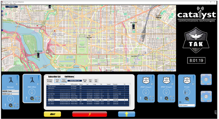
InterLoc™ from Catalyst Communications Technologies obtains location and other meta data from standards based LMR and broadband mission critical push-to-talk (MCPTT) networks, providing location and personal identification information from portable radios, mobile radios and MCPTT devices. InterLoc is now able to display the location of TAK users alongside LMR and MCPTT users on the same map.
What’s especially unique is that InterLoc™ is not an AVL (automatic vehicle location) service – it’s a Personal Location Service. By capturing this information from standards based LMR and broadband systems, a dispatcher can track the location of an individual even when they are outside a vehicle. Now, this information can be sent to TAK servers running TAK map and location services.
The TAK app uses GPS and on-screen maps to give the user a real-time view of the incident. This new situational awareness capability includes weather conditions and first responder tracking to see where units are located, as well as terrain and other topographical elements.
As an information broker, TAK provides server interfaces and Plug-ins to import and export situational awareness data securely and in real time. Catalyst utilizes a secure TAK server connection for communication of location and emergency status information.
InterLoc™ – Personal Location Services from Standards Based LMR and Broadband Systems
Many Automatic Vehicle Location (AVL) systems rely on proprietary devices that are mounted in a vehicle and use commercial cellular networks to retrieve location. The InterLoc™ system from Catalyst is unique because it does not use expensive map licensing or cellular data charges, making the system very cost effective compared to typical AVL solutions. InterLoc™ typically uses and displays Open Street Map map tiles and its user interface is intimately tied to Catalyst’s Dispatch and Interoperability solutions. This allows Dispatchers to initiate text and voice communications directly from the map. Maps can also display subscriber information including Emergency and Unit ID and Dispatchers can find and track user resources on the map and display user location history with the click of a mouse. Multiple maps, and multiple types of maps, can be simultaneously displayed, and customized maps can help dispatchers manage their unique and immediate needs. Now, this information from subscriber devices can be passed to the TAK servers for display on TAK mapping software. Additionally, InterLoc is able to display the location of TAK users alongside the location of its LMR and MCPTT users.
InterLoc™ with TAK is available from Catalyst today for integration with radio systems using standard compliant LMR (P25 and DMR) and certain standards compliant 3GPP MCPTT broadband systems.